Church nearby Haatso Pentecost Church
Ghana
Church nearby Haatso Pentecost Church
Haatso Pentecost Church
Haatso, Ghana
contacts phone
:
+233
Latitude:
5.6694889
, Longitude:
-0.2053113
larger map & directions
read more
nearest Church
148 m
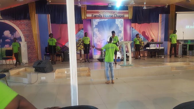
Family House chapel
Ecomog, haatso, Road
Church
read more
234 m
Grace Gospel Ministries
222 Haatso-Atomic Road, Accra
Church
read more
392 m
Doxa Citadel
Haatso
Church
read more
442 m
Shalom PRESBY
Haatso
Church
read more
541 m
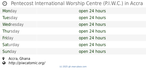
Pentecost International Worship Centre (P.I.W.C.)
Accra
Church
read more
695 m
GLOBAL REVIVAL MINISTRIES (REVIVAL CITY)
Haatso-Atomic Road, Accra
Church
read more
695 m
Power Praise Chaple
Haatso-Atomic Road, Accra
Church
read more
718 m
Lighthouse Chapel International Haatso
Unnamed Road, Haatso
Church
read more
725 m
Perfecting Faith Chapel
Haatso-Atomic Road, Haatso
Church
read more
836 m
Oasis Of Joy International Fellowship
Haatso
Church
read more
840 m
Peniel Revelation Worship Centre
Haatso
Church
read more
842 m
Ascension Methodist Church
Haatso
Church
read more
937 m
Seventh-day Adventist Church, Haatso
Haatso
Church
read more
976 m
Super Market Haatso
Haatso-Atomic Road, Accra
Church
read more
1.025 km
Action Chapel Int - Faith Temple
Jasmine Street, Accra
Church
read more
1.054 km
PCG-Shalom Congregation
Haatso
Church
read more
1.064 km
Harris Chapel Baptist Church
Haatso
Church
read more
1.077 km
Transfiguration Anglican Church,Haatso
Haatso
Church
read more
1.266 km
Healing Ways Chapel International
Dicko Dee Villa, Haatso- Ecomog Near, 1
Church
read more
1.32 km
PEOPLE OF PRAISE CHAPEL,Restoration Assembly
Fourth Avenue, Haatso
Church
read more
1.487 km
Bohye Asaase Prayer Camp
Ghana
Church
read more
1.83 km
Abu Gyan 家里Ascension Congregation
Ghana
Church
read more
1.935 km
Charismatic Evangelistic Ministry
North Legon
Church
read more
2.253 km
Legon Interdenominational Church
University Of Ghana, Accra
Church
read more
2.32 km
St. Thomas Aquinas Catholic Church
Volta Road, Accra
Church
read more
📑
all categories
Accounting
Administrative area level 1
Administrative area level 2
Airport
Amusement park
Aquarium
Art gallery
Atm
Bakery
Bank
Bar
Beauty salon
Bicycle store
Book store
Bus station
Cafe
Campground
Car dealer
Car rental
Car repair
Car wash
Casino
Cemetery
Church
City hall
Clothing store
Colloquial area
Convenience store
Courthouse
Dentist
Department store
Doctor
Electrician
Electronics store
Embassy
Finance
Fire station
Florist
Food
Funeral home
Furniture store
Gas station
General contractor
Grocery or supermarket
Gym
Hair care
Hardware store
Health
Hindu Temple
Home goods store
Hospital
Insurance agency
Intersection
Jewelry store
Laundry
Lawyer
Library
Liquor store
Local government office
Locality
Locksmith
Lodging
Meal delivery
Meal takeaway
Mosque
Movie rental
Movie theater
Moving company
Museum
Natural feature
Neighborhood
Night club
Painter
Park
Parking
Pet store
Pharmacy
Physiotherapist
Place of worship
Plumber
Point of interest
Police
Post office
Premise
Real estate agency
Restaurant
Roofing contractor
Route
Rv park, camping
School
Shoe store
Shopping mall
Spa
Stadium
Storage
Store
Subpremise
Subway station
Supermarket
Synagogue
Taxi stand
Train station
Transit station
Travel agency
University
Veterinary care
Zoo
sublocality level 1
↑