Church nearby Zimmerman Presbytarian Church
Ghana
Church nearby Zimmerman Presbytarian Church
Zimmerman Presbytarian Church
Ghana Ghana
contacts phone
:
+233
Latitude:
5.7343427
, Longitude:
-0.2058864
read more
nearest Church
927 m
Jesus Save Power Chapel
Ghana
Church
read more
940 m
Abokobi Presbyterian Church
Church
read more
956 m
Kharis City
Church
read more
1.167 km
International Central Gospel Church
Ghana
Church
read more
1.291 km
Pantang Presbyterian Church Of Ghana
Ghana
Church
read more
1.335 km
Our Lady Of Fatima Catholic Church
Ghana
Church
read more
1.488 km
Lighthouse Chapel International,Pantang Branch
Church
read more
1.533 km
The Church of Pentecost, Pantang Central
Church
read more
1.547 km
HIS BANNER CHRISTIAN CENTRE
Pantang West
Church
read more
1.647 km
Highier Life Christian Ministry
Church
read more
1.654 km
Bible Standard Church
Church
read more
1.855 km
king's dominion chapel int'l
Ghana
Church
read more
1.861 km
Bethsaida Wisdom Tree Chapel
East, Ga
Church
read more
1.922 km
Global Peace Christian Centre (GPCC)
South Abokobi, Ablor-Adjei, Accra
Church
read more
1.989 km
Asaph Corner
Boi, Accra
Church
read more
2.559 km
Light Of Fire Sanctuary
Ghana
Church
read more
2.572 km
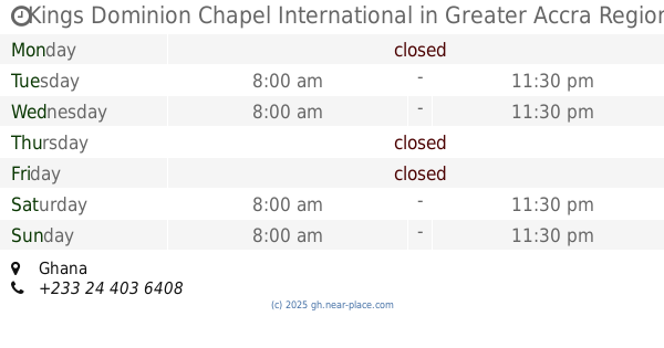
Kings Dominion Chapel International
Ghana
Church
read more
2.851 km
HighCity Church - Fire Chapel
Ghana
Church
read more
2.917 km
The Lord's Sanctuary ICGC
Ghana
Church
read more
3.198 km
Newlife Assembly of God, Oyarifa
Ghana
Church
read more
3.242 km
Our Lady Seat Of Wisdom Catholic Church, Oyarifa
Church
read more
3.295 km
Synagogue Church Of All Nations
1, Segun Irefin Street, Ikotun - Egbe Road,, lagos, Adenta Municipality
Church
read more
3.303 km
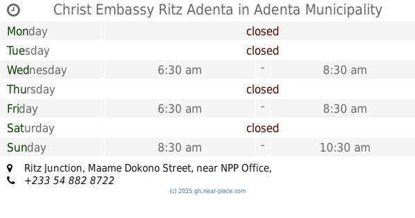
Christ Embassy Ritz Adenta
Ritz Junction, Maame Dokono Street, near NPP Office
Church
read more
3.731 km
Charismatic Church of Christ
Ashongman Estates
Church
read more
4.158 km
Lighthouse Chapel International
F95/96
Church
read more
📑
all categories
Accounting
Administrative area level 1
Administrative area level 2
Airport
Amusement park
Aquarium
Art gallery
Atm
Bakery
Bank
Bar
Beauty salon
Bicycle store
Book store
Bus station
Cafe
Campground
Car dealer
Car rental
Car repair
Car wash
Casino
Cemetery
Church
City hall
Clothing store
Colloquial area
Convenience store
Courthouse
Dentist
Department store
Doctor
Electrician
Electronics store
Embassy
Finance
Fire station
Florist
Food
Funeral home
Furniture store
Gas station
General contractor
Grocery or supermarket
Gym
Hair care
Hardware store
Health
Hindu Temple
Home goods store
Hospital
Insurance agency
Intersection
Jewelry store
Laundry
Lawyer
Library
Liquor store
Local government office
Locality
Locksmith
Lodging
Meal delivery
Meal takeaway
Mosque
Movie rental
Movie theater
Moving company
Museum
Natural feature
Neighborhood
Night club
Painter
Park
Parking
Pet store
Pharmacy
Physiotherapist
Place of worship
Plumber
Point of interest
Police
Post office
Premise
Real estate agency
Restaurant
Roofing contractor
Route
Rv park, camping
School
Shoe store
Shopping mall
Spa
Stadium
Storage
Store
Subpremise
Subway station
Supermarket
Synagogue
Taxi stand
Train station
Transit station
Travel agency
University
Veterinary care
Zoo
sublocality level 1
↑