School nearby Comeva Montessori
Ghana
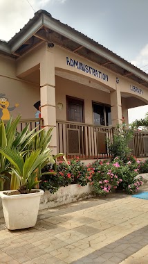
School nearby Comeva Montessori
Comeva Montessori
Ga, East Ghana
contacts phone
:
+233
Latitude:
5.700309
, Longitude:
-0.1888416
read more
nearest School
581 m
Opoku-Agyemang Sch.
Norwood City
School
read more
608 m
Bernard Academy
School
read more
698 m
Science and Technology Education Centre (Sci Tech)
Ghana
School
read more
760 m
The Bridge of Hope
Norwood City
School
read more
877 m
North Legon School Complex
Freshers Complex School, north, Accra
School
read more
1.029 km
Myredeve Little College (Agbogba)
Agbogba - Ashongman Road, Accra
School
read more
1.085 km
Sakora Bridge Of Hope School
Norwood City
School
read more
1.098 km
Kevboat Pre-School
Nii Kodia Road
School
read more
1.112 km
Global Theological Seminary
School
read more
1.186 km
Eunicharles International School
School
read more
1.211 km
Wass Primary
School
read more
1.282 km
Nadat School
School
read more
1.524 km
Articulate Kids International School
Adenta Municipality
School
read more
1.602 km
The Light Academy, Adenta
Okpoti Street
School
read more
1.627 km
Maribea Kids School
House No. 12, Kristo Asafo Area, Adenta, Accra, Nyanyo Street
School
read more
1.865 km
Gloryland School
Agbogba
School
read more
1.871 km
Danestrol Auto
113 Ecowas Road, Madina
School
read more
1.9 km
Ebenezer Mission Academy
Ghana
School
read more
1.934 km
Agbogba JSS
Ghana
School
read more
1.942 km
Pantang Hospital Junior Secondary School
Adenta Municipality
School
read more
1.961 km
Tot To Teen School
Madina
School
read more
2.029 km
Dobloo Tstoo St.
N4, Madina
School
read more
2.11 km
Golden Gate International School
Adenta Municipality
School
read more
2.261 km
Jakcint Academy
east
School
read more
2.301 km
Shine International School
Ashongman-Abokobi Road
School
read more
📑
all categories
Accounting
Administrative area level 1
Administrative area level 2
Airport
Amusement park
Aquarium
Art gallery
Atm
Bakery
Bank
Bar
Beauty salon
Bicycle store
Book store
Bus station
Cafe
Campground
Car dealer
Car rental
Car repair
Car wash
Casino
Cemetery
Church
City hall
Clothing store
Colloquial area
Convenience store
Courthouse
Dentist
Department store
Doctor
Electrician
Electronics store
Embassy
Finance
Fire station
Florist
Food
Funeral home
Furniture store
Gas station
General contractor
Grocery or supermarket
Gym
Hair care
Hardware store
Health
Hindu Temple
Home goods store
Hospital
Insurance agency
Intersection
Jewelry store
Laundry
Lawyer
Library
Liquor store
Local government office
Locality
Locksmith
Lodging
Meal delivery
Meal takeaway
Mosque
Movie rental
Movie theater
Moving company
Museum
Natural feature
Neighborhood
Night club
Painter
Park
Parking
Pet store
Pharmacy
Physiotherapist
Place of worship
Plumber
Point of interest
Police
Post office
Premise
Real estate agency
Restaurant
Roofing contractor
Route
Rv park, camping
School
Shoe store
Shopping mall
Spa
Stadium
Storage
Store
Subpremise
Subway station
Supermarket
Synagogue
Taxi stand
Train station
Transit station
Travel agency
University
Veterinary care
Zoo
sublocality level 1
↑